


Botanical Districts of Australia
Originally prepared by by Lee Halasz
ACT | NSW | NT | QLD | SA | TAS | VIC | WA | Oceanic Islands
AUSTRALIAN CAPITAL TERRITORY : C
CAN - ACT - Canberra only
CJB - Jervis Bay Territory (often included in NSC)
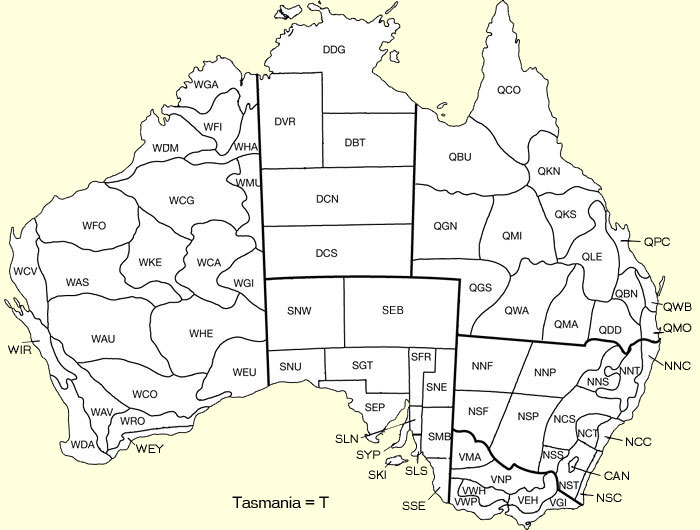
NEW SOUTH WALES: N
(Harden, G.J. (ed) (1990) Flora of New South Wales – Volume 1, New South Wales University Press.)
NNF - North Far Western Plains
NNP - North Western Plains
NNS - North-west Slopes
NNT - Northern Tablelands
NNC - North Coast
NSF - South Far Western Plains
NSP - South Western Plains
NCS - Central-west Slopes
NCT - Central Tablelands
NCC - Central Coast
NSS - South-west Slopes
NST - Southern Tablelands
NSC - South Coast (includes Jervis Bay Territory)
CJB - Jervis Bay Territory
NLH - Lord Howe Island
NORTHERN TERRITORY: D
(Chippendale, G. (1972) Checklist of Northern Territory Plants. Proceedings of the Linnean Society of New South Wales 96(4): 209.)
DDG - Darwin and Gulf
DVR - Victoria River
DBT - Barkly Tablelands
DCN - Central Australia North
DCS - Central Australia South
QUEENSLAND: Q
(Henderson, R.J.F. (1974) Solanum nigrum L. (Solanaceae) and related species in Australia. Contributions from the Queensland Herbarium 16: 80.)
QCO - Cook
QBU - Burke
QKN - Kennedy North
QGN - Gregory North
QMI - Mitchell
QKS - Kennedy South
QLE - Leichhardt
QPC - Port Curtis
QGS - Gregory South
QWA - Warrego
QMA - Maranoa
QBN - Burnett
QWB - Wide Bay
QDD - Darling Downs
QMO - Moreton
SOUTH AUSTRALIA: S
(Jessop, J.P. and Toelken, H.R. (1986) Flora of South Australia - Part 1, South Australian Government Publishing Division.)
SNW - North-west
SEB - Eyre Basin
SNU - Nullarbor
SGT - Gairdner - Torrens Basin
SFR - Flinders Ranges
SNE - North-east
SEP - Eyre Peninsula
SLN - Lofty North
SMB - Murray Basin
SYP - Yorke Peninsula
SLS - Lofty South
SKI - Kangaroo Island
SSE - South-east
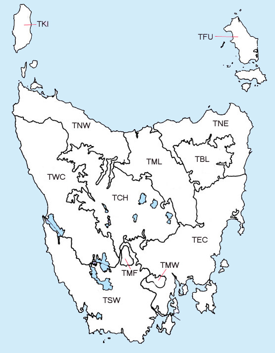
TASMANIA: T
(Orchard, A.E. (1988) A natural regions map for Tasmania. Proceedings of the Royal Society of Tasmania 122(2): 48.)
T - Tasmania
TBL - Ben Lomond
TCH - Central Highlands
TEC - East Coast
TFU - Furneaux Group
TKI - King Island
TMF - Mount Field
TML - Midlands
TMW - Mount Wellington
TNE - North East
TNW - North West
TSW - South West [TSD - South West (dolerite); TSQ - South West (quartzite)]
TWC - West Coast
TMA - Macquarie Island
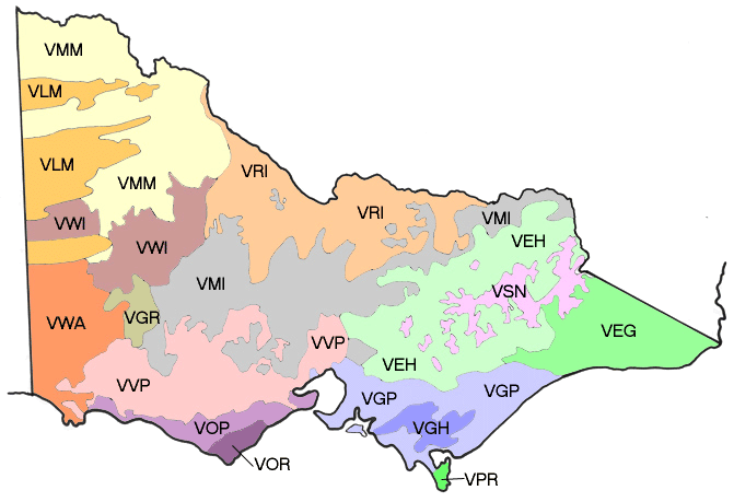
VICTORIA: V
(Conn, B.J. (1993) Natural regions and vegetation of Victoria, in Flora of Victoria - Volume 1, Foreman, D.B and Walsh, N.G. (eds), Inkata Press.)
Old system (used on top map) |
New system |
VMA - Mallee VWP - Western Plains VNP - Northern Plains VWH - Western Highlands VEH - Eastern Highlands VGI - Gippsland |
VMM - Murray Mallee
VLM - Lowan Mallee
VWI - Wimmera
VWA - Wannon
VGR - Grampians
VRI - Riverina
VMI - Midlands
VVP - Victorian Volcanic Plain
VOP - Otway Plains
VOR - Otway Range
VEH - Eastern Highlands
VGP - Gippsland Plain
VGH - Gippsland Highlands
VPR - Wilsons Promontory
VSN - Snowfields
VEG - East Gippsland
|
WESTERN AUSTRALIA: W
(Beard, J.S. (1980) A new phytogeographic map of Western Australia. Western Australian Herbarium Research Notes 3: 45.)
WGA - Gardner
WFI - Fitzgerald
WDM - Dampier
WHA - Hall
WCG - Canning
WMU - Mueller
WFO - Fortesque
WCV - Carnarvon
WAS - Ashburton
WKE - Keartland
WCA - Carnegie
WGI - Giles
WAU - Austin
WHE - Helms
WIR - Irwin
WDA - Darling
      (includes WDR:Drummond, WDL:Dale, WME:Menzies, WWA:Warren)
WAV - Avon
WCO - Coolgardie
WEU - Eucla
WRO - Roe
WEY - Eyre
OCEANIC ISLANDS: I, N or T
Commonwealth Territories
ICK - Cocos (Keeling) Island
ICH - Christmas Island
ICS - Coral Sea Islands Territory
INO - Norfolk Island
IAS - Ashmore & Cartier Islands
IHE - Heard & McDonald Islands
AAT - Australian Antarctic Territory
State Administered Islands
NLH - Lord Howe Island (part of New South Wales)
TMA - Macquarie Island (part of Tasmania)